Discover the last 355 km of one on the most important rivers in Spain, which runs for over 1.038 km to end in Portugal, making it the longest river in the peninsula
Both Cáceres and Badajoz have bicycle renting systems, on Badajoz the system has a fixed timetable from 7:30 am to 10:30 pm everyday, afer this time, you should return your bike in any of the posts availables. Also, you have plenty of stores available where you can rent a bike in case you need it for longer routes.
Extremadura is a gastronomical and natural paradise that is sure to surprise you. Because a host of recipes inherited from olden times have been passed down from generation to generation to our days, and now delight us with their exquisite flavours.
Upon hearing the word 'ibérico' the first thing that comes to mind is Iberian ham. And it is precisely in Extremadura where one of the best cured hams of the Iberian Peninsula is made, due to the large extension of dehesa, or pasture lands, in the region. The pigs, which have long, fine, muscular legs, are used to running several kilometres in search of acorns every day - a foodstuff which, along with the pasture, gives their meat that singular texture, flavour and fragrance. Like the rest of the cold meats: cured loin, black pudding, chorizo, spiced sausage, blood sausage...
In general, all of Extremadura's gastronomy is top quality. Because who could resist trying one of the region's stews or a dish of migas, chanfaina or zorongollo? Simply, yet very delicious cuisine.
And if we start talking about desserts... A portion of técula mécula, the recipe for which is guarded jealously by the bakery in Olivenza where it is made; arrope (grape concentrate),perrunillas (cookies), bollos de chicharrones (sweets made with pork crackling), hornazos(pies), sapillos or repápalos en leche (fritters)... Because something sweet always goes down well.
And sweet indeed are the region's fruits, starting with the cherries, of which Extremadura is the first producer in Spain and the holder of the "Cereza del Jerte" Denomination of Origin. But it is also an important producer of plums as the region ranks number one in Europe in terms of volume.
The cheeses are important, too, so much so that it is said that in the Middle Ages they were used as currency. The Tortas del Casar, the cheeses of La Serena and Los Ibores, all of which have Denomination of Origin, are famous. And you can also try some of the goat's cheeses from La Raya, a goat's cheese from Gata, from Las Hurdes, from Castiblanco or from La Vera...
And what could be better to wash down these delicacies with than a local wine, from the Ribera del Guadiana Denomination of Origin? Or a pitarra wine. And to finish up, let's drink a toast to your trip with a glass of cava from Almendralejo: to the gastronomy tour of Extremadura you are about to embark on... Welcome to a new world of flavour - of Iberian flavour.
Badajoz has a service of 11 urban bus routes and Cáceres 12 of them which will make you easier you trips around the city. Also, you can take buses on both bus stations that will take you to any town of the region and even the whole country.
The Tagus Nature Trail runs for over 850 km from its start in the Teruel province until its end at Cáceres, passing through Guadalajara, Madrid and Toledo. A journey in the footsteps of the longest river of the Iberian peninsula, whose final stages, exactly 355 km, pass through Extremadura.
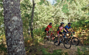
Prepared for MTB, the stages in Extremadura are divided into total eight ranging between 40 and 60 km length each, following for the most part the signposted track of the GR 113 path but including the necessary alternative tracks to overcome the obstacles that along the way inhibit MTB.

STAGE 1: Puente del Arzobispo – Villar del Pedroso – Valdelacasa del Tajo – Garvín
The stage begins at Puente del Arzobispo, the provincial border between Cáceres and Toledo. The route runs towards the south parallel to the EX-387 road toward Villar del Pedroso, a town where you may visit the Carnaval de Ánimas Interpretation Centre, a deep-rooted local festival.
The stage continues on the los Huertos road with the Altamira mountain range facing you at all times. A route that links with the Valdelacasa to Carrascalejo path, an area where meadows start to appear with low hill areas until you reaching Valdelacasa de Tajo. We will leave this town to take the Peraleda de San Román path, crossing the Zarzalejos stream and go towards Garvín, end of the stage.
STAGE 2: Garvín – Peraleda de San Román – Bohonal de Ibor
The stage starts at Garvín and goes on the Camino Real to Peraleda San Román. Next to the Gualija river bridge the route deviates from the original track of the Tagus Nature Trail to follow the Fresnedoso path, which after a steep climb leads to the raña de las Mesillas, an important geosite that we will find in the surroundings of the Villuercas-Jara Geopark.
At this point, the stage joins the Passage Through Geopark route. Thus, it takes the Navalmoral de la Mata to Castañar Ibor path and goes down the valley unto Bohonal de Ibor. The Roman ruins of Augustóbriga are located about 2 km off the track to the north of this town on the shores of the Valdecañas reservoir.
STAGE 3: Bohonal de Ibor – Mesas de Ibor – Valdecañas del Tajo – Higuera de Albalat – Serrejón – Toril
The stage starts at Bohonal de Ibor on the CC-19 road to reach the Ibor river near the Veredas bridge. The route continues parallel to the road up to Mesas de Ibor, where an asphalted stretch a cemented track begins that will lead us to Valdecañas de Tajo. From here the path continues along the CC-148 road, on a stretch which is not signposted as a Nature Trail.
At the Garganta de Descuernacabras natural swimming pool, an ideal space to take a break, a steep climb begins until reaches the Higuera de Albalat town.
From this last point, over the Almaraz path, passing through a landscape of beautiful oak tree meadows; we will arrive at Albalat bridge, with the Tagus river crossing. After passing the Arrocampo reservoir towards Serrejón, we will enter the Monfragüe Biosphere Reserve. Finally, the route continues up to Toril, end of the stage.
STAGE 4: Toril – Villarreal de San Carlos – Serradilla
This stage begins at Toril, where the Monfragüe Biosphere Reserve Interpretation Enter is located. A remarkable oak trees meadow will accompany the cyclist for about 10 km, until the road that connects La Bazagona with Saltos de Torrejón. Very close to this point, you may enjoy the first vantage point in the area, the impressive Portilla del Tiétar, where it is easy to spot species such as the imperial eagles, griffon vultures, black stork and eagle owl.
The route continues until reaching Villarreal de San Carlos, the nerve centre of the Monfragüe National Park, where there is an Information Office and several interpretation centres related to this natural area.
From here the route diverts from the GR 113 path until the end of stage in Serradilla. The flight of birds of prey will always accompany us and it wont be a surprise if we come across deer's, therefore we must take extra precautions.
STAGE 5: Serradilla – Casas de Millán – Cañaveral – Garrovillas de Alconétar
The stage starts at Serradilla on the old Talaván path until reaching Casas de Millán. From here the route continues to the west meeting the high-speed railway line for the first time, just where the route leaves the Monfragüe Biosphere Reserve to reach Cañaveral.
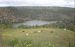
From this point the route turns to the south and joins the Via de la Plata track. Once on the shores of the Alcántara reservoir, the stage joins the the N-630 to successively cross the riverbeds of the Tagus and Almonte rivers.
The route continues until reaching the Garrovillas de Alconétar town, end of the stage. Viewing its arcaded square, declared as an historic-artistic monument will impress you.
STAGE 6: Garrovillas de Alconétar – Mata de Alcántara – Alcántara
The stage starts at Garrovillas de Alconétar crossing the Pinares de Garrovillas Special Bird Protection Area, an interesting stretch of umbrella pine forest that are used by species such as the black stork to reproduce. The town itself boasts of this environmental protection for the colony of lesser kestrel present in the vicinity of its square and church.
We will descend unto the shores of the Alcántara reservoir. After crossing Mata de Alcántara, the route takes the Recovera path, at which point you may once again see the reservoir water and go towards Alcántara, end of the stage.
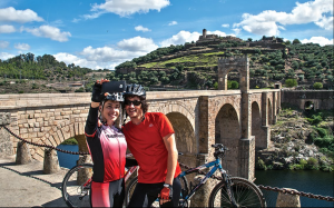
This town, apart from the magnificent Roman Bridge, declared as the Best Corner of Spain in 2014; also has a very important monumental complex, notable the San Benito Convent. Alcántara is also a gateway to the Tagus International Natural Park, and the visitors may visit its Interpretation Centre in this town of Cáceres.
STAGE 7: Alcántara – Membrío – Carbajo
The stage starts at Alcántara following the Cañada Real de Gata to enter the plains of Brozas and Alcántara. During the journey the visitor may spot the flight of great bustards, bustards, and Montagu's harriers, among other species. All birds that live in the nearby Tagus International Natural Park.
The route gently goes ahead to descend the Salor river to enter the natural space mentioned above. The climb is of continuous ascent unto Membrío, always with the foothills of the Sierra de San Pedro mountain range dominating the skyline. At this point in the path its will be quite habitual to encounter herds of deer. The route continues until reaching the Carbajo town, end of the stage.
STAGE 8: Carbajo – Santiago de Alcántara – Herrera de Alcántara – Cedillo
The stage starts at Carbajo until reaching Santiago de Alcántara. In this town of Cáceres one may visit two interpretation centres: Péndere, intended to showcase the various environmental and scenic treasures of the Tagus International Natural Park; and Megalithic, that gathers information on the important dolmens site of the municipality.
The route starts at Santiago over the Cedillo path, a track that passes through meadows and scrubland until reaching the town of Herrera de Alcántara. This municipality is where the main jetty of Balcón de Tajo, the tourist boat that offers river tours through the natural park.
Owing to cycling issues, from Herrera onwards the route deviates from the nature trail to go towards Cedillo on the EX-116 road initially and the CC-125 later, where both the stage and the route end.